
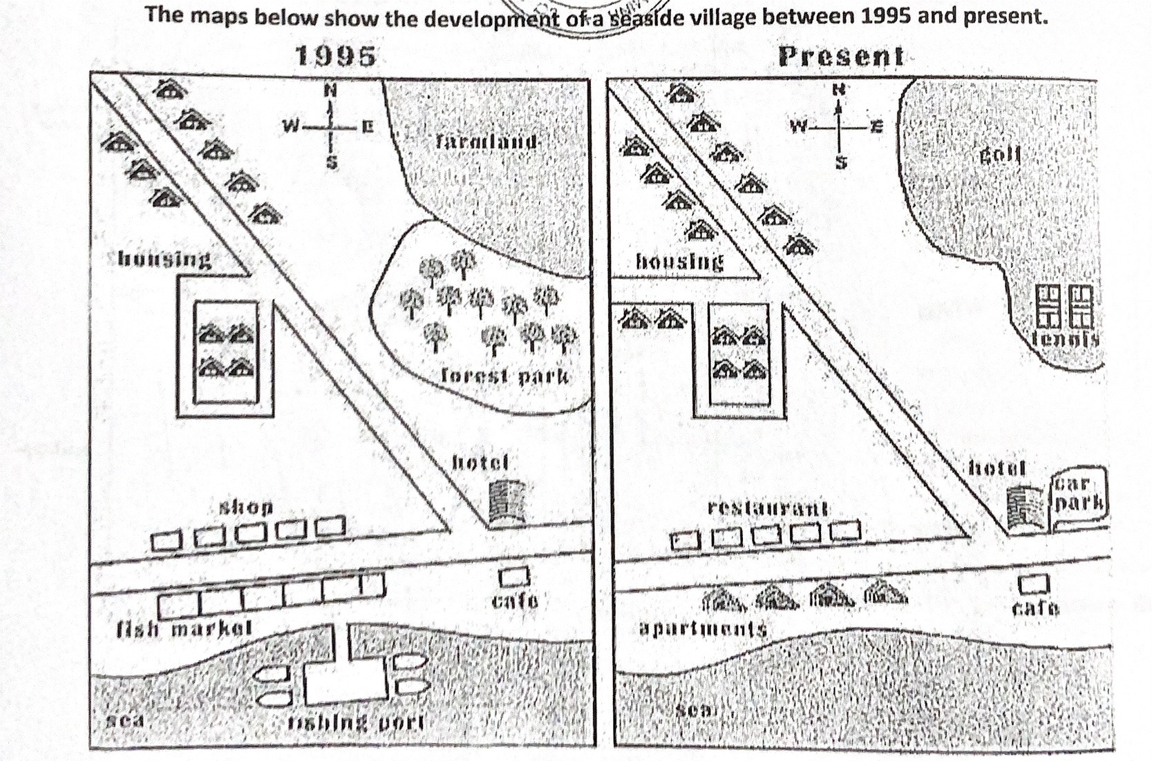
The maps illustrate how the coastal village has transformed from 1995 to present. Overall, the coastal village has undergone significant changes, transforming from a fishing industry into residential and recreational sites. Additionally, the farmland has been replaced by sports facilities, while the road has been expanded to provide greater accessibility. Beginning with the northeastern part of the village, the agricultural site and forest park have been flattened and converted into recreational amenities, including golf and tennis courts. Furthermore, additional houses were constructed in the northwest corner along the road for more residents. Moreover, the road network has also been widened in order to give better accessibility for the housing area in the northwest. Moving onto the southern area, the shops were converted into restaurants. Similarly, the opposite side of the road where used to be a fish market was demolished to make way for modern apartments. In addition, the fishing port has been entirely removed, while the hotel remained in place near the junction and opposite the cafe. In the southeastern corner, a new car park has been built next to the hotel to offer convenience to visitors and locals.
รายละเอียดตัวอย่าง
The maps below show the development ofa seaside village between 1995 and present.
18/07/2026 14:33 6.5 คะแนน
หัวข้อ
The maps below show the development ofa seaside village between 1995 and present.
จำนวนคำ: 190
แผนภูมิ/กราฟ
Essay
คะแนนรวม
6.5±0.5
ดีพอใช้
คะแนนเกณฑ์การเขียน
TA6.0
CC7.0
LR7.0
GRA7.0
Task Achievement6.0
เป้าหมาย: 7.0
ข้อผิดพลาด:0
Coherence & Cohesion7.0
เป้าหมาย: 7.0
ข้อผิดพลาด:2
Lexical Resource7.0
เป้าหมาย: 7.0
ข้อผิดพลาด:2
Grammar & Accuracy7.0
เป้าหมาย: 7.0
ข้อผิดพลาด:0
คลิกข้อความที่ไฮไลต์ในเรียงความเพื่อดูคำแนะนำรายละเอียดเพื่อพัฒนา
การวิเคราะห์เชิงลึก
Task 1 - Academic Writing
4 tools available
บทความตัวอย่าง - IELTS Writing Task 1
ยังไม่มีบทความตัวอย่าง
กดปุ่มด้านล่างเพื่อวิเคราะห์และสร้างบทความตัวอย่างคุณภาพสูงสำหรับ Task 1