
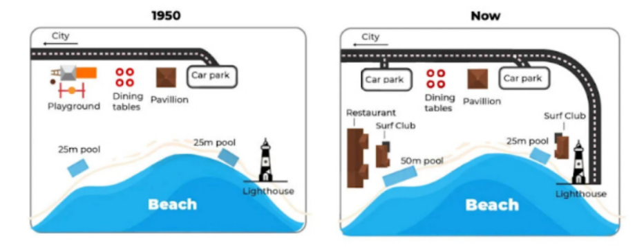
The maps illustrate the changes that a beachfront area underwent in Australia between 1950 and today. Overall, this beachfront area has a beach in the south and a quite simple path of transportation, which runs from the city in the west to the foreshore. Moreover, the beachfront area also has some amenities, being useful for tourists. Over the period, the beachfront area has constructed some new facilities, while few infrastructure has been replaced with new amenities. In the north, the end of the road was a car park in 1950, but now it has expanded, stretching to a lighthouse by the coast. In the northwest corner, there is a playground located next to the path, which was removed to make way for another car park. While dining tables, the pavilion remained the same position throughout the period. In the seashore, there were two outside swimming pools, one near the southwest and the other near the southeast, each 25 metres long. But now, one near the southwest has been expanded to double its original length. Furthermore, in the north of each swimming pool a Surf Club has been created. Notably, there was an enormous restaurant constructed behind the Surf Club in the West.
নমুনা বিস্তারিত
The maps below show a beachfront area in 1950 and today
18/07/2026 15:12 6.0 স্কোর
টপিক বা বিষয়
The maps below show a beachfront area in 1950 and today
শব্দ সংখ্যা: 202
চার্ট/গ্রাফ
Essay
সামগ্রিক স্কোর
6.0±0.5
মোটামুটি
রাইটিং মানদণ্ড স্কোর
TA6.0
CC7.0
LR6.0
GRA6.0
Task Achievement6.0
লক্ষ্যমাত্রা: 7.0
ভুল:1
Coherence & Cohesion7.0
লক্ষ্যমাত্রা: 7.0
ভুল:4
Lexical Resource6.0
লক্ষ্যমাত্রা: 7.0
ভুল:3
Grammar & Accuracy6.0
লক্ষ্যমাত্রা: 7.0
ভুল:0
উন্নতির জন্য বিস্তারিত পরামর্শ দেখতে প্রবন্ধের হাইলাইট করা যেকোনো লেখায় ক্লিক করুন।
গভীর বিশ্লেষণ
Task 1 - Academic Writing
4 tools available
নমুনা রচনা - IELTS Writing Task 1
কোনো নমুনা রচনা নেই
টাস্ক ১-এর জন্য উচ্চমানের নমুনা রচনা বিশ্লেষণ এবং তৈরি করতে নিচের বাটনে ক্লিক করুন।