
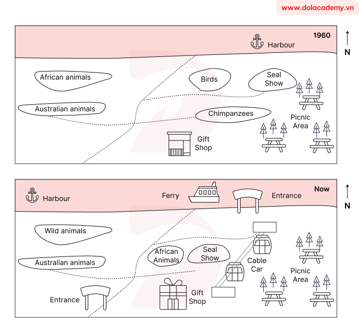
The two maps illustrate the significant redevelopment of an Australian zoo, its layout in 1960 with its current configuration. Overall, the zoo has undergone a substantial modernization, primarily characterized by the significant enhancement of its transportation infrastructure and accessibility. The most striking developments are the establishment of two new entrances and the introduction of both a ferry service and a cable car system. In 1960, the zoo was accessible via a northern harbour. The eastern sector featured a Picnic Area adjacent to a Seal Show. Centrally, enclosures for birds and chimpanzees were located near the Gift Shop, while the western area was designated for housing African and Australian animals. By the present day, access has been diversified with a new Entrance and ferry terminal by the harbour, and a second Entrance in the south-west. A cable car now links this south-western entrance directly to the Picnic Area, and the original Gift Shop has been significantly expanded. Furthermore, the central enclosures for birds and chimpanzees have been replaced by African Animals, whose former western habitat now houses 'Wild animals'. The Seal Show and Picnic Area, however, have remained unchanged
รายละเอียดตัวอย่าง
The maps show the changes that have taken place at an Australian Zoo between 1960 and now. Summarize the information by selecting and reporting the main features and make comparisons where relevant.
20/07/2026 04:23 7.0 คะแนน
หัวข้อ
The maps show the changes that have taken place at an Australian Zoo between 1960 and now. Summarize the information by selecting and reporting the main features and make comparisons where relevant.
จำนวนคำ: 188
แผนภูมิ/กราฟ
Essay
คะแนนรวม
7.0±0.5
ดีมาก
คะแนนเกณฑ์การเขียน
TA7.0
CC7.0
LR7.0
GRA7.0
คลิกข้อความที่ไฮไลต์ในเรียงความเพื่อดูคำแนะนำรายละเอียดเพื่อพัฒนา
การวิเคราะห์เชิงลึก
Task 1 - Academic Writing
4 tools available
บทความตัวอย่าง - IELTS Writing Task 1
ยังไม่มีบทความตัวอย่าง
กดปุ่มด้านล่างเพื่อวิเคราะห์และสร้างบทความตัวอย่างคุณภาพสูงสำหรับ Task 1