
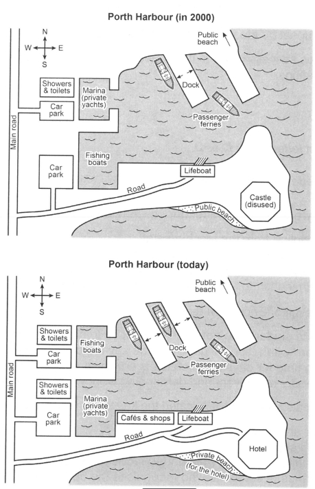
The maps below illustrate changes in Porth Harbour from the year 2000 to its currently appearance. Overall the map show that Porth Harbour has transformed into a developed and tourist-friendly destination, although some original features like the public beach still remain. In 2000, Main Road ran from north to south along the western side of the Harbour.At its northern end were a car park and showers and toilets, while a marina for private yachts was situated to the east. Further south, there was another car park, followed by an area for fishing boats and a lifeboat station. In the south-eastern part of the harbour stood a disused castle next to a public beach.Today, the marina and the fishing-boat area have switched locations. A second dock for passenger ferries has also been added beside the original one. In the southern part of the harbour, showers and toilets have been built near the car park, while cafés and shops have been added close to the lifeboat station. Finally, the former castle has been converted into a hotel, and the adjacent beach is now reserved for hotel guests.
Sample Detail
The plans below show a harbour in 2000 and how it looks today. Summarise the information by selecting and reporting the main features, and make comparisons where relevant.
20/07/2026 11:25 7.0 points
Topic
The plans below show a harbour in 2000 and how it looks today. Summarise the information by selecting and reporting the main features, and make comparisons where relevant.
Word count: 185
Chart/Graph
Essay
Overall Scores
7.0±0.5
Good
Writing Criteria Scores
TA7.0
CC7.0
LR7.0
GRA7.0
Click on any highlighted text in the essay to view detailed suggestions for improvement.
Deep Analysis
Task 1 - Academic Writing
4 tools available
Sample Essay - IELTS Writing Task 1
No sample essay
Click the button below to analyze and generate a high-quality sample essay for Task 1.