
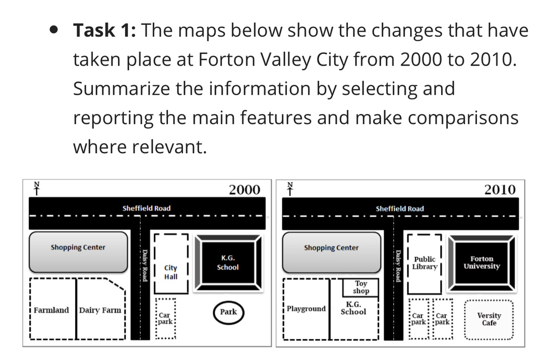
The two maps illustrate the alterations that occurred in a city called Forton Valley between 2000 and 2010. Overall, the area underwent a number of dramatic changes, the most significant of which were the conversion of some structures and the redevelopment of some places. In the north-western corner of the area, a road named Sheffield remained unchanged, and a similar pattern was observed in a large shopping center. By stark contrast, a farmland and a dairy farm which were situated in the southern section were transformed into a playground, and a school named K.G with a smaller toy shop at the top-right corner of the school, respectively. In the central area, there were no changes that were made to the Daisy road. However, a city hall and the big old K.G. school in the eastern section experienced significant changes, with these buildings being converted into a public library and a university of Forton, in turn. Finally, in the eastern corner, a big park was demolished to make way for a coffee shop called Versity, whereas a car park near the Daisy road was extended into two distinct ones.
รายละเอียดตัวอย่าง
Task 1: The maps below show the changes that have taken place at Forton Valley City from 2000 to 2010. Summarize the information by selecting and reporting the main features and make comparisons where relevant.
21/07/2026 07:23 6.5 คะแนน
หัวข้อ
Task 1: The maps below show the changes that have taken place at Forton Valley City from 2000 to 2010. Summarize the information by selecting and reporting the main features and make comparisons where relevant.
จำนวนคำ: 188
แผนภูมิ/กราฟ
Essay
คะแนนรวม
6.5±0.5
ดีพอใช้
คะแนนเกณฑ์การเขียน
TA6.0
CC7.0
LR7.0
GRA7.0
คลิกข้อความที่ไฮไลต์ในเรียงความเพื่อดูคำแนะนำรายละเอียดเพื่อพัฒนา
การวิเคราะห์เชิงลึก
Task 1 - Academic Writing
4 tools available
บทความตัวอย่าง - IELTS Writing Task 1
ยังไม่มีบทความตัวอย่าง
กดปุ่มด้านล่างเพื่อวิเคราะห์และสร้างบทความตัวอย่างคุณภาพสูงสำหรับ Task 1