
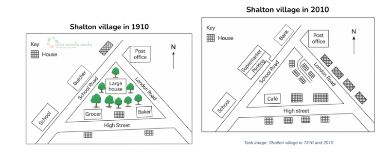
The maps compare the layout of Shalton village between 1910 and 2010. Overall, Shalton village became much more urbanized over the period. The significant changes were the addition of commercial areas and the replacement of green spaces. Besides that, a school and a post office remained unchanged. In 1910, Shalton village was organized around three road namely School Road, London Road, High Street. A large house was surrounded by many trees in the center of the village. In addition, there was a school and a butcher along School Road, a grocer and a baker could be spotted in High street. Furthermore, a post office was located to the north of the village. In 2010, the green spaces were demolished to make room for several new houses with an inner road. The former butcher was replaced by a supermarket with its parking area along school road. In addition, a bank was built near school road and a number of houses were constructed along London Road and High Street. Moreover, the school and the post office remained in the same position.
รายละเอียดตัวอย่าง
Shalton village in 1910 and 2010
21/07/2026 17:41 7.0 คะแนน
หัวข้อ
Shalton village in 1910 and 2010
จำนวนคำ: 179
แผนภูมิ/กราฟ
Essay
คะแนนรวม
7.0±0.5
ดีมาก
คะแนนเกณฑ์การเขียน
TA7.0
CC7.0
LR7.0
GRA7.0
คลิกข้อความที่ไฮไลต์ในเรียงความเพื่อดูคำแนะนำรายละเอียดเพื่อพัฒนา
การวิเคราะห์เชิงลึก
Task 1 - Academic Writing
4 tools available
บทความตัวอย่าง - IELTS Writing Task 1
ยังไม่มีบทความตัวอย่าง
กดปุ่มด้านล่างเพื่อวิเคราะห์และสร้างบทความตัวอย่างคุณภาพสูงสำหรับ Task 1