
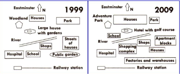
The 2 maps illustrate how eastminster had developed from 1999 to 2009 Overall, while several existing landmarks remained unchanged, the town underwent significant transformations. These changes include the construction of recreational, industrial, residential purposes. Regarding to 1999 map, the area was basically equipped with essential residential amenities. In the center of the map, a river bisected the town from western to eastern. A woodland and houses were situated at that northwest side, and a park was located at the other end. A large house with gardrens was built next to the river. The southern of the town used to feature a hosiptal, shcool, shops, and streets of houses across the river, positioned opposite the public garden and railway station. Moving to the map in 2009, eastminster had shifted to a urbanized town. specifically, a adventure park were builted to replace the woodland and the large house with gardens had been converted into a hotel with golf course. Similarity, at the south side of river, the school, the streets of houses, and the public garden were demolished to make way for a shopping complex, apartment blocks and factories and warehouses, respectively. The houses were increased in size, while the park had been made smaller. However, hospital, shops and railway station remained unchanged after a decade.
รายละเอียดตัวอย่าง
the maps give information about the development of eastminster over 10 years from 1999 to 20009
22/07/2026 03:44 6.5 คะแนน
หัวข้อ
the maps give information about the development of eastminster over 10 years from 1999 to 20009
จำนวนคำ: 214
แผนภูมิ/กราฟ
Essay
คะแนนรวม
6.5±0.5
ดีพอใช้
คะแนนเกณฑ์การเขียน
TA7.0
CC7.0
LR6.0
GRA6.0
คลิกข้อความที่ไฮไลต์ในเรียงความเพื่อดูคำแนะนำรายละเอียดเพื่อพัฒนา
การวิเคราะห์เชิงลึก
Task 1 - Academic Writing
4 tools available
บทความตัวอย่าง - IELTS Writing Task 1
ยังไม่มีบทความตัวอย่าง
กดปุ่มด้านล่างเพื่อวิเคราะห์และสร้างบทความตัวอย่างคุณภาพสูงสำหรับ Task 1