
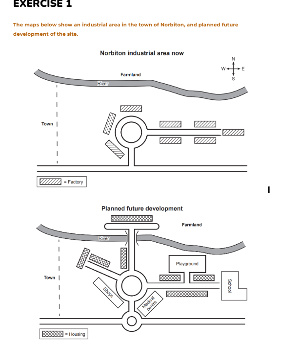
The two maps illustrate how Norbition industrial zone is expected to develop in the future. Overall, all the manufacturing areas are going to be transformed into residential areas accompanied with a wide range of essential amenities. At the present, a river serves as a natural boundary, separating the farmland on the Northside from the industrial zone. At the center, there is a big roundabout, surrounded by many factories, which branches off into two roads on the east and south sides. Noticeably, in the future all the former factory site will be demolished and converted into new living areas. A new bridge is going to be constructed, allowing for new housing and a new road which connects the farm land with the central area. From the roundabout, one new road heading north west will be introduced while the previous on the east is going to branch off a new road into the north. This development led to an introduction of a playground and a school, creating a beneficial area for children. Additionally, a new smaller roundabout will be built on the road at the bottom of the map, which helps residents effectively approach new amenities, including shops and healthcare systems.
รายละเอียดตัวอย่าง
The maps below show an industrial area in the town of Norbiton, and planned future development of the site.
22/07/2026 14:11 7.0 คะแนน
หัวข้อ
The maps below show an industrial area in the town of Norbiton, and planned future development of the site.
จำนวนคำ: 199
แผนภูมิ/กราฟ
Essay
คะแนนรวม
7.0±0.5
ดีมาก
คะแนนเกณฑ์การเขียน
TA7.0
CC7.0
LR7.0
GRA7.0
คลิกข้อความที่ไฮไลต์ในเรียงความเพื่อดูคำแนะนำรายละเอียดเพื่อพัฒนา
การวิเคราะห์เชิงลึก
Task 1 - Academic Writing
4 tools available
บทความตัวอย่าง - IELTS Writing Task 1
ยังไม่มีบทความตัวอย่าง
กดปุ่มด้านล่างเพื่อวิเคราะห์และสร้างบทความตัวอย่างคุณภาพสูงสำหรับ Task 1