
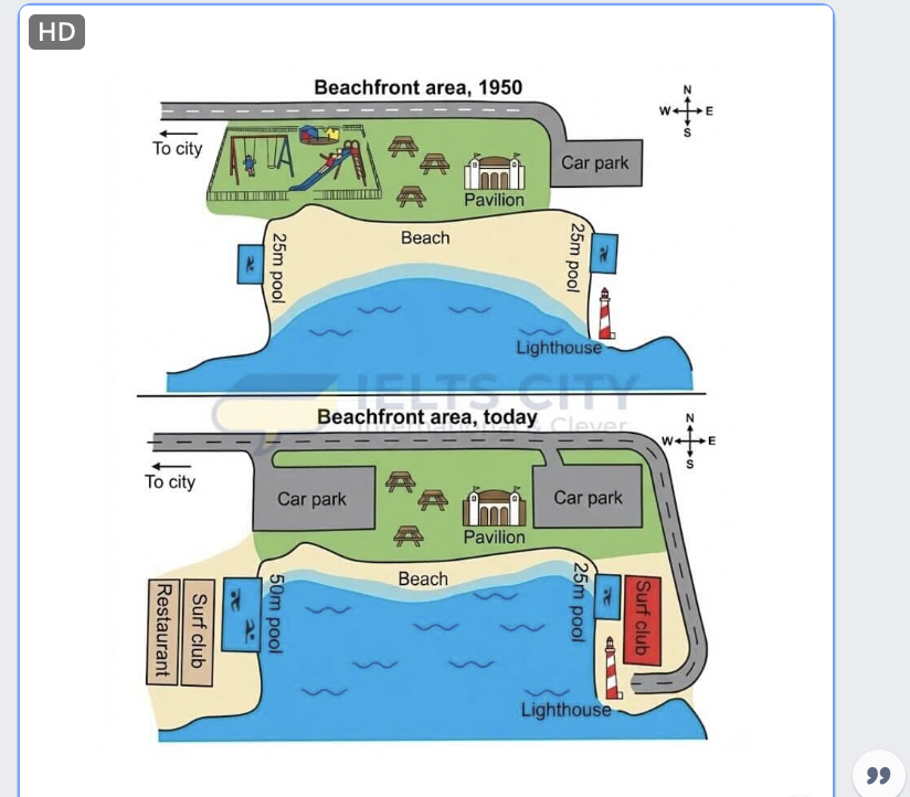
The given pictures depict changes of an Australian beachfront are in 1950 and today. Overall, it is noticeable that this area undergone a series of alterations. While the pavilion and the picnic area remain unchanged, the site has experienced substantial additions to its swimming, dining and transport facilities to attract more tourist. In terms of the upper half of the map, in 1950, the beachfront consisted of a children playground, a picnic area which is right next to the pavilion and the car park nearby. In the present day, due to the development of tourism, the area added a new car park where the playground area was located and the repositioned original car park while the picnic site and the pavilion unchanged. Commencing to the bottom half, the beach site contained a wide shore with 2 25m pools located beside it. Additionally, the beachfront also had a lighthouse near the coastline. The nowadays area are filled with amenities, the left coast witnessed the appearance of a restaurant, a new surf club and the enlargement of the current pool, which is double the side of the old one. The left side contains an original 25m pool, a surf club and a bigger lighthouse. Furthermore, the road was prolonged connecting the area to the city.
รายละเอียดตัวอย่าง
The maps show a beachfront in Australia in 1950 and today.
23/07/2026 08:35 6.0 คะแนน
หัวข้อ
The maps show a beachfront in Australia in 1950 and today.
จำนวนคำ: 213
แผนภูมิ/กราฟ
Essay
คะแนนรวม
6.0±0.5
ดีพอใช้
คะแนนเกณฑ์การเขียน
TA6.0
CC6.0
LR6.0
GRA6.0
คลิกข้อความที่ไฮไลต์ในเรียงความเพื่อดูคำแนะนำรายละเอียดเพื่อพัฒนา
การวิเคราะห์เชิงลึก
Task 1 - Academic Writing
4 tools available
บทความตัวอย่าง - IELTS Writing Task 1
ยังไม่มีบทความตัวอย่าง
กดปุ่มด้านล่างเพื่อวิเคราะห์และสร้างบทความตัวอย่างคุณภาพสูงสำหรับ Task 1